GPS - County Hunting - County Lines
and
Map Accuracy Standards
or
Where am I?
WD3P
On the trip home from the 3M County Hunting Mini Convention in
Murfreesbuor, TN in October 2000, I was using a Garmin GPS 12 to let me know how far I
I had to go before arriving at the next county. I had placed a route in the GPS which
was simply the location of each county line I was going to cross. This was as an aid
so that I knew how far it was to the next county. Unlike many county hunters I do not
stop on the county line and transmitt from two counties at the same time. The other
I had the GPS doing was recording my postiton every few minutes of the trip. This was
I was doing just for the fun of it.
I was quite surprised when I arrived at the county line of Wyoming and McDowell,
WV on Rt 52 and the GPS told me I was still several hundered feet from the line. That county
line runs along the mountain ridge. The sign for the county line seemed to be placed a bit
prior to the top of the mountian so I drove on South a bit till I was sure I was past the ridge
of the mountian and out of Wyoming County before I began to transmit from McDowell County.
Under the rules of county hunting the sign is considered to be the real line. And
under those rules I could park next to the sign and claim to be transmitting from both counties.
That is not a bad rule as something must determine the line. The solution is not to say don't
transmit from the line and hand out two counties at once. I could park a foot one side of
the sign and give out the first county, then move to a foot the other side of the sign and give
out the second county. If the sign is not in the correct spot I really was the same county
both times. So something must determine the line, and the sign is as good as anyother option.
Never the less a misplaced sign is always of interest to me.
When I arrived home I did a further examination on the postion of the sign. The GPS
had been tracking my postion so it had recorded several positon fixes as I sat in one spot and
tranmitted from McDowell County. These were all within about 20 feet of each other. So I took
the average positon and plotted it on the 7.5 minute maps that the U.S. Geological Survey
publishes. These are likely the most accurate maps around.
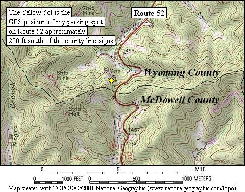 At least it will be hard to get
a map witch is better and is easliy available. I was surprised when I noted that postion fix
that the GPS had given me were not only severl hundred feet form the county line on the map,
they were also part way down the mountian. Clearly something was wrong. You can see how far off
the GPS spot was on the map at the right. The yellow dot on the map is the positon given by
the GPS.
At least it will be hard to get
a map witch is better and is easliy available. I was surprised when I noted that postion fix
that the GPS had given me were not only severl hundred feet form the county line on the map,
they were also part way down the mountian. Clearly something was wrong. You can see how far off
the GPS spot was on the map at the right. The yellow dot on the map is the positon given by
the GPS.
That examination led me to the issue of just how accurate are the map. It turns out
they are not as good as I thought. The U.S. Geological Survey actually has
"Map Accuracy Standards."
And these are published on the web for all to see. The basic standard is that on the 7.5
minute map the postion should be accurate within 40 feet of "truth." This is not quite as
good as a GPS can give but a lot better than what I was seeing. But hold on, the real standards
are also determined by how they are applied. In this case the U.S. Geological Survey takes
seveal points on each map and verifies their accurracy. However the weakness in the testing
system is in how the points are choosen. What they take are "well-defined points." These could
be the corner of a large building, or the intersection of two roads, or it could be a survey
benchmarker. So a single road winding seveal miles thought the woods really has no standards
applied to it. The same is true for most county lines. Unless there is a benchmarker on the
county line there are no standards. This does not mean that they are inaccurate. What it does
mean is that without any quality control on the process there could be "significant" error.
In the case of the county line I am seeing what look like errors of 300-500 feet. To most
people these kinds of errors are not a problem. To others they are.
Is this situation unique? I have not done a major search however there are other
cases equally bad. One interesting case is on Rt. 30 in VA at the county line of Caroline and King
William. Here there are two well placed signs, one each side of the road. The pavement has as
definite break at the location of the signs. It is as if each county did not want to pave the
road as it entered the other county.
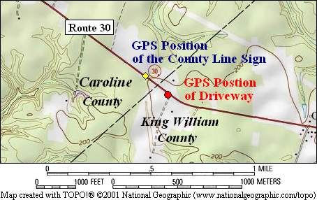 However the signs are not where the topographic maps places the county line. Rather sign are
seveal hundered feet West of where the map claims they sould be. In the map on the left signs
are at the point marked by the yellow diamond. As I made two trips to this county line I got smart on the
second trip and also got a GPS spot of a small road to a farm house a short distane into King
William County. This is the point marked with the red dot. The Topo map does of very good job of placing
this road. So as far as the county line which is right - the map or the sign? I do not
know.
However the signs are not where the topographic maps places the county line. Rather sign are
seveal hundered feet West of where the map claims they sould be. In the map on the left signs
are at the point marked by the yellow diamond. As I made two trips to this county line I got smart on the
second trip and also got a GPS spot of a small road to a farm house a short distane into King
William County. This is the point marked with the red dot. The Topo map does of very good job of placing
this road. So as far as the county line which is right - the map or the sign? I do not
know.
Least you think all the problems are with the maps I offer one more example. This
is one of my favorites as the Virginia Department of Transportation have told me that they
delibertly have misidentifed the county line. They did this to avoid confusion on the part of
of the public. But it sure confused me the first time I saw it. The county line I am thinking
of is where Rt 460 from Richmond to Suffolk, VA crosses from Sussex County into Surry County and
then into Southampton County. The road is in Surry County for only about 700 feet. For this
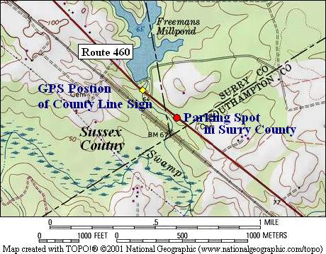 reason the Virginia Department of Transportation decided to only identify the change from Sussex
to Southamption County. Thus the signs along the road identify a county line that does not exist.
This is all done to reduce confusion.
The map on the right demonstrates the situation. As it turns out the sign, the yellow diamond,
is where the county line signs are placed. They are directly over where the creek crosses
under the road. For the county hunters, don't even think or running this line as you would
have to park right in the roadway. That is just as well as all admit the marked county line
does not exist. I had expected to find that the sign was at least placed in Surry County,
but alas it is in Sussex County. What I did find which is nice is that there is a convienent
place to pull over on the side of Rt 460 that the maps and the GPS places in Surry County.
That point is marked with the red dot on the map. Now I don't have to drive down one of
the back roads to get into Surry County. In this case though it is clear that the signs
are wrong, so the maps provide the better information this time.
reason the Virginia Department of Transportation decided to only identify the change from Sussex
to Southamption County. Thus the signs along the road identify a county line that does not exist.
This is all done to reduce confusion.
The map on the right demonstrates the situation. As it turns out the sign, the yellow diamond,
is where the county line signs are placed. They are directly over where the creek crosses
under the road. For the county hunters, don't even think or running this line as you would
have to park right in the roadway. That is just as well as all admit the marked county line
does not exist. I had expected to find that the sign was at least placed in Surry County,
but alas it is in Sussex County. What I did find which is nice is that there is a convienent
place to pull over on the side of Rt 460 that the maps and the GPS places in Surry County.
That point is marked with the red dot on the map. Now I don't have to drive down one of
the back roads to get into Surry County. In this case though it is clear that the signs
are wrong, so the maps provide the better information this time.
None of this is to say that the underlying Topograhic maps are not of high quality.
What it tell us is that county line markings on the map can be in disagreement with the signs
placed by the local department of transportation. As the last example illustrate there are
compromises in the placement of these signs. They are not intended from the most part to be
precise indicators of the loaction of the county line. But also the standards for the
Topographic maps as such that they are not readily applied to indefinite items on the map
such as a county line. Thus errors of a few hundred feet on such items can be expected.
I plan on doing some further explorations in the future. There are many signs that are just
where the map claims they should be. There are also many cases where the county line runs down
a road and there is only one sign for the county line.
The maps on this page were produced with the TOPO! map progam. In this case I used the Mid-Atlantic
USA version of the program to produce the maps. This program is produced by the
National Geographic Society. They
have a very nice Extended User License that grants legal permission to use copyrighted
reproductions from TOPO! In return, they only ask that the corresponding TOPO! overlay
files be posted on the National Geographic MapXchange website. I plan to keep posted at
that website a file with all of the county lines I have check posted. I can also send a copy
of the TOPO! file with the county lines I have checked for use by those who have the TOPO!
program.
The WD3P Home Page
E-Mail: WD3P